
Vicinity GIS - New Zealand
Win32 및 64, 한국어Methodical, Cad Consulting
Georeferenced Transportation Cad Model for the Country of New Zealand
일반 사용 지침
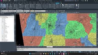
Vicinity GIS can be used for creating vicinity maps, without the need of attaching an image to your CAD file. The models can be used for referencing Major and Minor streets and highways in addition to Land District limits with labels and shading into your CAD models, all on separate layers and lineweights.
Land Districts can be located using the Autodesk® AutoCAD® "Find" command.
스크린샷


명령
설치/설치제거
Just extract the .dwg file to your preferred CAD model folder.
추가 정보
알려진 문제
문의
회사 이름: Methodical, Cad Consulting
지원 연락처: xyz.3@aol.com
작성자/회사 정보
Methodical, Cad Consulting
지원 정보
Comments or questions about Vicinity GIS Models can be sent to xyz.1@aol.com
버전 내역
| 버전 번호 | 버전 설명 |
|---|---|
|
1.0.0 |
Initial Release |
