
Vicinity GIS - Louisiana, US
Win32 e 64, PortuguêsMethodical, Cad Consulting
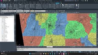
Georeferenced Transportation Cad Model for the State of Louisiana, United States
Instruções de uso geral
Vicinity GIS can be used for creating vicinity maps, without the need of attaching an image to your CAD file. The models can be used for referencing Interstate, U.S., State, County, and local streets and highways in addition to County limits with labels and shading into your CAD models, all on separate layers and lineweights.
Capturas de tela


Comandos
Instalação/Desinstalação
Just extract the .dwg file to your preferred CAD model folder.
Informações adicionais
Problemas conhecidos
Contato
Nome da empresa: Methodical, Cad Consulting
Contato de suporte: xyz.3@aol.com
Informações do Autor/Empresa
Methodical, Cad Consulting
Informações de suporte
Comments or questions about Vicinity GIS Models can be sent to xyz.1@aol.com
Histórico de versões
| Número da versão | Descrição da versão |
|---|---|
|
1.0.0 |
Initial Release |
