
Vicinity GIS - New Zealand
Win32 и Win64, РусскийMethodical, Cad Consulting
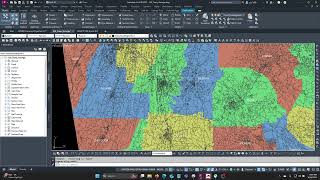
Georeferenced Transportation Cad Model for the Country of New Zealand
Общие инструкции по использованию
Vicinity GIS can be used for creating vicinity maps, without the need of attaching an image to your CAD file. The models can be used for referencing Major and Minor streets and highways in addition to Land District limits with labels and shading into your CAD models, all on separate layers and lineweights.
Land Districts can be located using the Autodesk® AutoCAD® "Find" command.
Снимки экрана


Команды
Установка/удаление
Just extract the .dwg file to your preferred CAD model folder.
Дополнительная информация
Известные проблемы
Контактные данные
Название компании: Methodical, Cad Consulting
URL-адрес компании: https://apps.autodesk.com/en/Publisher/PublisherHomepage?ID=4MG2UFZZPNAAQXX8
Контактные данные службы поддержки: xyz.3@aol.com
Информация о компании/авторе
Methodical, Cad Consulting
Сведения о поддержке
Comments or questions about Vicinity GIS Models can be sent to xyz.1@aol.com
Журнал версий
| Номер версии | Описание версии |
|---|---|
|
1.0.0 |
Initial Release |
