
Vicinity GIS - Georgia, US
Win32 および 64, 日本語Methodical, Cad Consulting
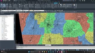
Georeferenced Transportation Cad Model for the State of Georgia, United States
一般的な使用手順
Vicinity GIS can be used for creating vicinity maps, without the need of attaching an image to your CAD file. The models can be used for referencing Interstate, U.S., State, County and local streets and highways in addition to County limits with labels and shading into your CAD models, all on separate layers and lineweights.
スクリーンショット


コマンド
インストール/アンインストール
Just extract the .dwg file to your preferred CAD model folder.
追加情報
既知の問題
問い合わせ
会社名: Methodical, Cad Consulting
サポートの連絡先: xyz.3@aol.com
作成者/会社情報
Methodical, Cad Consulting
サポート情報
Comments or questions about Vicinity GIS Models can be sent to xyz.1@aol.com
バージョン履歴
| バージョン番号 | バージョンの説明 |
|---|---|
|
1.0.0 |
Initial Version |
