Vicinity GIS - Georgia, US
Opis
Vicinity GIS is a collection of CAD Models that consist of real world, geo-referenced features that represent Federal, State & local streets, highways and roads. Each CAD Model is geo-referenced to it's respective NAD83 State Plane coordinate system, in it's respective units. U.S. Survey feet for the United States and countries that use the Imperial System. Meters for countries that use the Metric System.
All CAD Models are in "dwg" format, which can be used in all Autodesk® product categories and has become the universal format for Engineering, Architectural, Structural and Geographic Industries. Models can be inserted or x-referenced into project design models and x-clipped to only show project specific areas that are needed.
Features contained in the models consist of polylines, text and hatch entities, which are separated by Layer, Color, Line Weight and Style. Each feature can be isolated, selected and/or searched by using standard Autodesk® AutoCAD® commands like "Qselect" and "Find" for text entities.
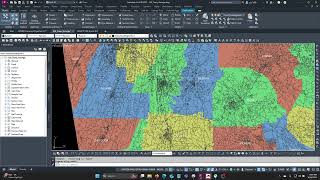
Each CAD Model also includes Governmental Administrative divisions (State, Province, County/Parish and/or City) separated by hatched areas, making them easily distinguishable and searchable.
Note: This app uses a dwg file (and not the standard App Store installer).