
Vicinity GIS - Tennessee, US
Win32 和 64, 繁體中文Methodical, Cad Consulting
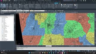
Georeferenced Transportation Cad Model for the State of Tennessee, United States
一般使用方式說明
Vicinity GIS can be used for creating vicinity maps, without the need of attaching an image to your CAD file. The models can be used for referencing Interstate, U.S., State, County and local streets and highways in addition to County limits with labels and shading into your CAD models, all on separate layers and lineweights.
Cities, Counties & Zipcodes can be located using the Autodesk® AutoCAD® "Find" command.
螢幕快照


指令
安裝/解除安裝
Just extract the .dwg file to your preferred CAD model folder.
其他資訊
已知問題
聯絡我們
公司名稱: Methodical, Cad Consulting
支援聯絡: xyz.3@aol.com
作者/公司資訊
Methodical, Cad Consulting
支援資訊
Comments or questions about Vicinity GIS Models can be sent to xyz.1@aol.com
版本歷程
| 版本號碼 | 版本說明 |
|---|---|
|
1.0.0 |
Initial Release |
