
SPCAD
Win64, EnglishGeneral Usage Instructions
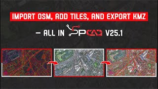
SPCAD offers 150+ CAD-GIS tools built for surveyors, engineers, urban planners, and geospatial professionals. It supports seamless import/export of SHP, KML, KMZ, TXT, LAS, and now GML formats.
With 150+ tools, users can:
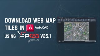
- Download OpenStreetMap and Web Map Tiles directly.
- Import geotagged images (EXIF) to auto-place photos spatially.
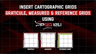
- Create cartographic grids: graticules, measured, and reference grids.
- Extract road/pipe centerlines from complex shapes.
- Export spatial data efficiently, including GML and KML.
- Add location-based QR codes and coordinate callouts.
- Draw Convex Hulls, shrinkwrap shapes, and generate map atlases.
- Create TINs, contours, and perform surface analysis in 3D.
- Subdivide land parcels with multiple smart methods and annotate them.
⚠️ Please uninstall older versions of SPCAD from the Control Panel before installing the latest one.
Screenshots


Commands
| Ribbon/Toolbar Icon | Command | Command Description |
|---|---|---|

|
IKML_SP |
Imports KML file into Autodesk® AutoCAD®. |

|
ISHP_SP |
Imports ESRI Shapefile into AutoCAD. |

|
SHRINKWRAP_SP |
Creates a concave polygon whose shrink can be adjusted. |

|
AVC_SP |
Generates an area-capacity curve from a TIN surface. |

|
DFA_SP |
Defines an alignment by selecting a Polyline object. |

|
CGRID_SP |
Inserts Cartographic Map Grid |

|
TCX_SP |
Creates cross sections from a TIN surface. |

|
CNTR_SP |
Generates contour lines from a TIN surface. |

|
IMPORTOSM_SP |
Imports OSM Vector Data (POIs, Raods, Waterways as Polylines, Buildings/Landuse as Polygons) along with Labels |

|
LPC_SP |
Creates longitudinal profile from contours. |

|
GCL_SP |
Marks Centerline from two opposite edges of Road/River/Canal etc |

|
MOSAIC_SP |
Mosaic the images attached in a drawing |

|
DDX_SP |
Divides a lot into parcels Perpendicular at mid of the side Lot line. The user creates the cutting edge along the side of Lot line. |

|
GNM_SP |
Download, Mosaic and Insert the Online Web Map Tiles |

|
DDY_SP |
Divides a lot into parcels on both sides of the plot Width Line.The user selects the plot Width Line already created in the drawing. |

|
PGMANAGER_SP |
POINT GROUP MANAGER to import, manage Points with different point Styles and Label Styles as Point Groups. |

|
DDZ_SP |
Divides a lot into n number of parcels perpendicular to the selected cutting edge (Front Lot Line). |
Installation/Uninstallation
The installer that ran when you downloaded this app/plug-in from the Autodesk App Store will start installing the app/plug-in. OR, simply double-click the downloaded installer to install the app/plugin. You may need to restart the Autodesk product to activate the app/plug-in. To uninstall this plug-in, exit the Autodesk product if you are currently running it, simply rerun the installer, and select the "Uninstall" button. OR, click Control Panel > Programs > Programs and Features (Windows 7/8.1/10/11) and uninstall as you would any other application from your system.
After installing SPCAD, make sure you have an active internet connection.
Note: The previous version of SPCAD must be uninstalled first from the Control Panel to install the current version.
For activation of the trial, watch the video: https://youtu.be/9rDagYNcHn8
A registration form will appear on the first run, requiring the Name, Email, Country, and Organization.
Fill out the form, click on "Register," and you will be sent a 5-digit code by CADOMATION to the provided email.
Enter the activation code to activate a fully functional trial for 14 days!
Additional Information
Known Issues
Contact
Author/Company Information
Support Information
Visit: https://cadomation.com/SPCAD
Version History
| Version Number | Version Description |
|---|---|
|
25.1 |
25.1 (Build 28.7.2025) New Features Point Group Manager: Manage and classify point groups. Import from files or DEM, and generate contours, convex hulls, shrink-wraps, and tables. Coordinate Label: Insert X/Y coordinate markers at any location. Cartographic Grid: Generate graticule, measured, or reference grids based on the active projected coordinate system. Mark Centerline: Generate a centerline from two selected polylines. Import OSM Vector Data: Download and insert OpenStreetMap vector data as CAD objects. Download Web Map Tiles: Fetch and insert tiles from online map sources into drawings. Geotagged Images: Read EXIF GPS data from photos and place them as georeferenced blocks. Mosaic Images: Create seamless image mosaics by spatially positioning geotagged images. Capture Screen as KMZ: Export a CAD window to Google Earth with georeferencing. Insert Vertex to 3D Polyline: Add a new vertex to selected 3D polylines. Offset of a 3D Polyline: Create a parallel 3D polyline with a defined offset. Complement Arc: Generate a complementary arc to form a full circle. DogBone: Add rounded arcs to sharp inside corners for a better fit in manufacturing. Best Fit Polyline: Draw a smooth polyline through multiple points. Straighten the Polyline: Replace curves with straight lines between selected polyline points. Break Distance: Divide a polyline into equal segments by length. Interpolate 3D Polyline: Automatically interpolate vertex elevations. Label Polyline with Table: Annotate polylines and export a data table. Export GML: Export selected objects in GML format. Export LOTs to GML Format: Export defined land parcels to GML. Improvements Progress Indicators Added: Most long-running tools now show execution progress bars. Optimized TIN Manager: Improved handling and faster performance for large terrain datasets. New Coordinate System Added: Added Swiss Grid support to the coordinate system list. Smarter UI Handling: Dialogs now have better input validation and layout organization. Improved Web Map Integration: Faster and more accurate downloading of map tiles with better error handling. |
|
25.0 |
Build 25.4.3.2029 Compatible with AutoCAD 2026 |
|
25.0 (Build 25.2.11.2019) |
New Features 1. Google Image: Import Google images (. geprint files) directly into your drawing for enhanced visualization. 2. TIN Manager: Comprehensive toolset to manage, edit, style, update, or delete Triangulated Irregular Networks (TINs), including: o Redefine TIN – Modify and redefine an existing TIN structure. o Elevation Legend – Display elevation data legend for better cartographic representation of terrain data ranges. o Raise/Lower TIN – Adjust elevation uniformly across the TIN. o Remove Elevation – Delete specific elevation data from the TIN. o Extract Points – Extract points from the TIN surface. o Add Point – Insert new points into the TIN Surface. o Remove Point – Delete selected points from the TIN. o Add Breakline – Insert breaklines to influence TIN triangulation. o Swap Edges – Modify triangle edges for better structure. o Clip TIN – Trim the TIN to a specified boundary. o Pack TIN – Optimize the TIN by removing unnecessary data. o Delete TIN – Remove an entire TIN surface from the drawing. 3. Quick Profile: Generate a quick longitudinal profile from a TIN surface for rapid analysis. 4. Quick Cross Section: Create quick cross sections from a TIN surface with minimal effort. 5. Convert to SPCAD TIN: Convert external 3D Faces into SPCAD’s TIN format for seamless integration. 6. Project to TIN: Project points (blocks, texts, and points) or linear entities (lines, polylines, and circles) onto a TIN surface. 7. TIN Merge: Merge two TIN surfaces into a single unified TIN surface for efficient modeling. 8. Perpendicular at Fixed Front Line: Divide a front line at a fixed perpendicular to ensure precise plot adjustments. Bug Fixes: 1. Fixed the startup error issue with the latest version of Microsoft Windows 11 24H2 Operating System 2. Optimized the extraction of cross-sections and longitudinal profiles from TIN surfaces, Contours, and other data. 3. Fixed the Volumetric Calculations Issues in TIN Surface Comparison tool. |
|
24.1 (Build 24.11.30.1308) |
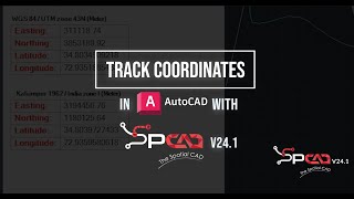
Nov 30,2024 Optimised Surface Volume Tool Oct 22, 2024 Polish and Spanish Language Translations corrected. Oct 04, 2024 Several new tools have been introduced in the latest version of the application to improve the workflow and user efficiency -Import DEM: Digital elevation raster can be imported as point, TIN and contours -Export DEM: TIN can be exported as raster DEM -Georeference Image: Raster georeferencing is now available in SPCAD -Voronoi Polygons: Area of influence can be created around the points using Thiessen polygons -Parallel area to Front lot line: Marking the front yard is now very easy with partitioning the lot by selecting the front lot line and stating the yard area. -Label Polylines: The length and bearing of line segments can be labeled efficiently. -Polygonize: Convert intersecting features into polygons. -Import LandXML: SPCAD is not importing the LandXML format to DWG -Export LandXML: Export the features from DWG to LandXML. -Geo distance: Measure the ground distance using cursor clicks. -Quick contours: For terrain understanding contours can be created quickly -Track Coordinates: displays the cursor’s coordinates in a separate palette For some of the tools bugs are fixed or their implementation has been changed. -Shrinkwrap: improve/change implementation -Create polyline/polygon from points: improve/change implementation -Import shapefile: improve/change implementation -Custom Transformation: improve/change implementation -Bing Maps: improve/change implementation -Import CSV: improve/change implementation -Create Tin: Bug fixes -Cut Polygon: Bug fixes -Create Contours: Bug fixes |
|
24.1 (Build 24.10.22.1222) |
Oct 22, 2024 Polish and Spanish Language Translations corrected. Oct 04, 2024 Several new tools have been introduced in the latest version of the application to improve the workflow and user efficiency -Import DEM: Digital elevation raster can be imported as point, TIN and contours -Export DEM: TIN can be exported as raster DEM -Georeference Image: Raster georeferencing is now available in SPCAD -Voronoi Polygons: Area of influence can be created around the points using Thiessen polygons -Parallel area to Front lot line: Marking the front yard is now very easy with partitioning the lot by selecting the front lot line and stating the yard area. -Label Polylines: The length and bearing of line segments can be labeled efficiently. -Polygonize: Convert intersecting features into polygons. -Import LandXML: SPCAD is not importing the LandXML format to DWG -Export LandXML: Export the features from DWG to LandXML. -Geo distance: Measure the ground distance using cursor clicks. -Quick contours: For terrain understanding contours can be created quickly -Track Coordinates: displays the cursor’s coordinates in a separate palette For some of the tools bugs are fixed or their implementation has been changed. -Shrinkwrap: improve/change implementation -Create polyline/polygon from points: improve/change implementation -Import shapefile: improve/change implementation -Custom Transformation: improve/change implementation -Bing Maps: improve/change implementation -Import CSV: improve/change implementation -Create Tin: Bug fixes -Cut Polygon: Bug fixes -Create Contours: Bug fixes |
|
24.1 (Build 24.10.4.1209) |
Oct 04, 2024 Several new tools have been introduced in the latest version of the application to improve the workflow and user efficiency -Import DEM: Digital elevation raster can be imported as point, TIN and contours -Export DEM: TIN can be exported as raster DEM -Georeference Image: Raster georeferencing is now available in SPCAD -Voronoi Polygons: Area of influence can be created around the points using Thiessen polygons -Parallel area to Front lot line: Marking the front yard is now very easy with partitioning the lot by selecting the front lot line and stating the yard area. -Label Polylines: The length and bearing of line segments can be labeled efficiently. -Polygonize: Convert intersecting features into polygons. -Import LandXML: SPCAD is not importing the LandXML format to DWG -Export LandXML: Export the features from DWG to LandXML. -Geo distance: Measure the ground distance using cursor clicks. -Quick contours: For terrain understanding contours can be created quickly -Track Coordinates: displays the cursor’s coordinates in a separate palette For some of the tools bugs are fixed or their implementation has been changed. -Shrinkwrap: improve/change implementation -Create polyline/polygon from points: improve/change implementation -Import shapefile: improve/change implementation -Custom Transformation: improve/change implementation -Bing Maps: improve/change implementation -Import CSV: improve/change implementation -Create Tin: Bug fixes -Cut Polygon: Bug fixes -Create Contours: Bug fixes |
|
1.0.0.3 (Build 24.5.29.554) |
June 10, 2024 In the latest version of SPCAD, we have addressed several bugs related to workflows and the inadvertent inclusion of special characters in annotations. Additionally, the new version features the inclusion of the Spanish language. All graphical user interfaces (GUIs) have been updated, now incorporating Spanish captions. Moreover, the release introduces a new tool to Import Digital Elevation Model (DEM) in 16-bit and 32 Bit GeoTiff Files. |
|
1.0.0.3 |
March 04, 2024 In the latest version of SPCAD, we have addressed several bugs related to workflows and the inadvertent inclusion of special characters in annotations. Additionally, the new version features the inclusion of the Spanish language. All graphical user interfaces (GUIs) have been updated, now incorporating Spanish captions. Moreover, the release introduces several new tools to enhance the user experience: 1. Elevate Points from TIN: This tool allows users to elevate points from a Triangulated Irregular Network (TIN), providing advanced functionality for terrain modeling. 2. Import GeoJSON: Users can now seamlessly import GeoJSON files, facilitating the integration of geographic data into the SPCAD platform. 3. Export GeoJSON: This tool enables users to export data in GeoJSON format, enhancing interoperability with other geographic information systems. 4. Quick LOT Subdivision: Users can perform rapid LOT subdivision based on specified criteria, including area, number of parcels, and percentage area. 5. Create Layer from Code: This feature allows for the creation of layers based on codes associated with points imported from CSV files. 6. Cut/Fill Analysis: The Cut/Fill analysis tool provides insights into earthwork volumes, assisting in project planning and design. 7. Import CSV and project lat/long as X/Y: Project latitude and longitude data to any coordinate system before importing CSV data into the drawing. 8. Parcel manager: Within the Cadaster panel, you'll find a parcel manager tool that enhances the interactivity of parcel annotation and management. 9. Online Help: Now, online help is available. If you are connected to the internet, pressing F1 will take you to the online help page. |
|
1.0.0.2 |
Initial release |
