
Coordinate Table
描述
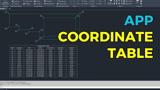
This app generates a coordinate table for polylines and 3D polylines. Using a dialog box, you can select whether to add labels to the objects and choose the information to include in the table: Segment, Elevation, Distance, 3D Distance (enable if there are 3D polylines on the selected objects), Bearing, and Azimuth. Each selected option adds a corresponding column to the table. The fixed columns are Point, East, and North. For the labels, you can configure the prefix, initial number, and text height. You can also set the precision for table data.
The inserted labels are multileader objects, consisting of a circle with text and a leader line. You can adjust the label position as needed. The table created is a native Autodesk® AutoCAD® table, not a collection of lines and text objects. After creation, you can insert or delete rows and columns and edit the text as required.


Excelente. Por favor, versión para versión 2026.