
TcpMDT Professional
描述
MDT is an application running on Autodesk® AutoCAD®, and has a wide range of easy-to-use tools. Its modular structure allows users to choose the most suitable options for their work.
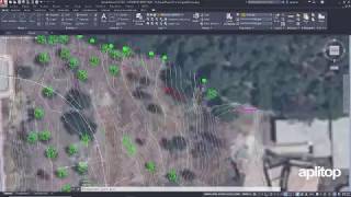
It includes all features of standard version and provides tools for designing horizontal and vertical alignments, drawing the project templates, area and volume reports, setting-out, virtual tour, measurements and quotations, water, sewerage and rainwater networks, etc. This software is suitable for all kind of surveying projects for roads, urbanizations, quarries... It is easily integrated into OpenBIM workflows, through exchange of IFC and LandXML files.
Note: This app uses a custom installer (and not the standard App Store installer).
试用版描述
Limitations: 30 days, 1000 points, maximum alignment length 1000m.


Es el mejor programa de topografia que yo he conocido
estoy con TcpMDT desde siempre yo creo que desde 1998
es un programa muy facil de manejar con un Soporte impecable
gracias por todo
I've been working with this tool during the last 4 years on a motorway construction in New Zealand. Due the geotechnical conditions on site we need an easy tool to redesign the batters of the motorway as fast as we can, and MDT has been a very helpfully to do that and get an accurate volume of the earthworks. It's a great application to design the temporary ponds, differents compound and the improvements of the design in the differents connections with others roads.
I've been working with this tool during the last 4 years on a motorway construction in New Zealand. Due the geotechnical conditions on site we need an easy tool to redesign the batters of the motorway as fast as we can, and MDT has been a very helpfully to do that and get an accurate volume of the earthworks. It's a great application to design the temporary ponds, differents compound and the improvements of the design in the differents connections with others roads.
I was introduced to the software in version 4 and have been an enthusiastic user of this software ever since. As main characteristics, I would highlight the ease of use, integration in AutoCad, and its versatility when solving problems for work. Highly recommend it
We are long term users. I think that was 1995 when we joined efforts. Now is going further in BIM, 3D and other software connections but the same functionalities. Ferrovial is over 50 licenses owner spreaded worldwide.
Support is agile and we append new solutions together according new markets and contracts. We keep on te same good relation.
Aplicación muy facil e intuitiva para aprender su manejo