Aerial Views by Plex-Earth
Opis
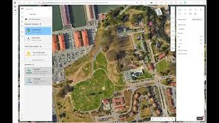
Unleash the Power of High-Resolution Aerial Imagery in Autodesk Forma®!
Plex-Earth's Aerial Views provides architects and engineers FREE access to unparalleled high-resolution satellite and aerial imagery inside Autodesk Forma®. Experience vivid, up-to-date views for your project areas directly within Forma, and travel back in time with extensive historical databases.
Whether scoping out real-world locations or incorporating environmental data into your designs, Aerial Views offers the clarity and accuracy you need.
Now everyone can see clearly from up above – with the most up-to-date and clearest images available!
- Scope out the real-world location in high resolution before you design
- Confidently incorporate the environmental reality into your superior design
- Security - Avoid expensive rework – save money, save time, and maybe your reputation!
Our Powerful Partnerships
This popular, all-powerful imaging platform brings you the very best satellite and aerial images from various providers.
Plex-Earth automatically imports and aligns updated high-res images from Airbus, Maxar, Nearmap, Hexagon, Google Maps and Azure Maps, right inside your Forma projects.
A Powerful Tool:
- Enjoy the benefits of the most up-to-date satellite imagery, and the power to look back in time to see how things have changed, by accessing the massive historical databases of Airbus & Maxar.
- Super-High Resolution – What good are bad images? Enjoy a clearer view of reality with pin-sharp resolutions of up to just 7.5 cm per pixel from our premium aerial imagery providers Nearmap and Hexagon.
Opis wersji testowej
Special Offer
THE REAL THING - You’re getting 3 months of access to the FULL POWER of Plex-Earth, until the end of 2023!