
ArcGIS for Autodesk® AutoCAD®

Digitally signed app
Descrição
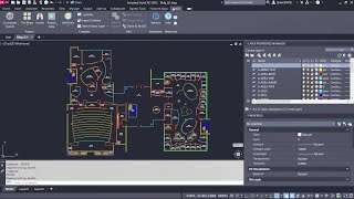
ArcGIS for Autodesk® AutoCAD® brings GIS to CAD professionals through the creation, collaboration, and managed editing of ArcGIS data in AutoCAD and Autodesk Civil 3D®. With this plug-in, design professionals such as civil engineers, surveyors, and CAD technicians leverage ArcGIS feature layers, maps, and imagery to make better-informed design decisions. Design professionals not only consume GIS data in desktop CAD applications but also data created within those environments are incorporated back into the systems of record. Better interoperability increases productivity by adding CAD users to workflows for creating and maintaining GIS data using their familiar CAD editing tools.
Benefits of ArcGIS for AutoCAD:
- Use your own organization’s ArcGIS Online or ArcGIS Enterprise content and data from ArcGIS Living Atlas of the World to inform your CAD drawings with geospatial context. Gain a geospatial understanding of your design project surroundings.
- Use GIS data in Autodesk while GIS users simultaneously work with the same data in ArcGIS, ensuring synchronization across both platforms.
- Provide your GIS team with CAD drawings that are compatible with ArcGIS software. These CAD drawings, enhanced with GIS attributes, can be used as a data source within the ArcGIS system.
- Use advanced GIS data management tools in your Autodesk design environment without extensive ArcGIS proficiency. ArcGIS for AutoCAD seamlessly integrates GIS into CAD workflows, providing self-service access to GIS content.
- Includes ArcGIS Indoors for AutoCAD—a tool that saves time preparing CAD floor plans for indoor mapping. Run diagnostic checks to identify common issues before importing floor plans into ArcGIS Indoors.
Latest enhancements:
- Users can instantly view and edit related GIS data, such as asset conditions from field inspections, directly within their designs. This helps civil engineers identify patterns, update asset attributes in bulk, and make more informed design recommendations using up-to-date information. The result is tighter CAD and GIS collaboration and faster, data-driven decision-making across project and asset teams.
- Civil engineers can now use asset centerline data from ArcGIS to better inform infrastructure designs, preserve alignment information, and enable civil-to-field workflows. With this enhancement, CAD users can add GIS web layers to contextualize project site plans, while stationed centerlines can be shared with field crews to help situate themselves accurately and efficiently on site.
- Customize ArcGIS for AutoCAD exactly the way you want. Use the Microsoft .NET SDK to automate workflows, extend functionality, and create experiences tailored to the needs of your organization. In addition to the AutoLISP SDK, users and developers now have more options to customize CAD/GIS workflows, including asynchronous processes.
Sign up for helpful resources to get started and stay informed about the latest releases of ArcGIS for AutoCAD.
Note: This app uses a custom installer (and not the standard App Store installer).


Really makes importing layers from ArcGIS online to Civil3D easy. Don't have to keep asking for someone to export them for me. Haven't really tested it to it's full extent, but importing layers is spot on.
ArcGIS for Autodesk is awesome and pretty useful add-in when you want to integrate GIS data into your CAD workflows – like adding a basemap or contextual GIS layers like cadaster data or utilities also with their attributes.
Moreover, it makes from the AutoCAD the ArcGIS client, which enables you to edit the GIS data (feature services) and share CAD data to GIS just right within AutoCAD and which openings though an GIS world for CAD users (you don´t need to learn a ArcGIS tool and workflows – but you will became a part of the GIS world as well).
So, if you are seeking a tool which integrates GIS to Autodesk world and enables the seamless collaboration on projects with your GIS colleagues, the ArcGIS for AutoCAD is the first choice.
I can't even get it to install for Autocad or Civil 3D was hoping to bring in some gdb county contour data but not additional tab for ArcGIS.
Mike Pope, Civil 3D or AutoCAD Map 3D doesn't require the plug-in since they are natively supported to open GDBs. Choose "Planning and Analysis" mode, Data panel, and MAPCONNECT using SHP/GDB as a new connection.