
Spot Elevations
A, M
Sistema operacional:
Idioma:
Descrição
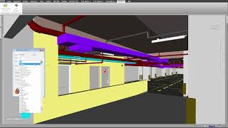
Spot the elevation of any element inside Autodesk® Navisworks® in real-time.
With this tool, you can visualize the real elevation of elements in Navisworks and establish a reference elevation number to measure relative elevations.
It will be very easy to verify the free clearance of pipes, ducts, cable trays and structural framings.
You can create SavedViewPoint with Elevation Marks with just one click. Similar to Autodesk® Revit®, you can create elevation marks for any point.
NEW FUNCTIONALITY!!! Now you can use all the SavedViewpoints to create a detailed report in EXCEL with our new tool SAVEDVIEWPOINTS EXPORTER that comes free with SPOT ELEVATIONS.


El Spot Elevations de Revit apliacdo a Navisworks.
Muy bueno!
Necesario sin duda, si necesitas obtener los niveles en navis sin necesidad de ver cada plano.
Al momento de realizar cambios o consultar informacion, nos toma una serie de pasos a seguir, pero con la implementacion de esta apliación todo es mas práctico
Thanks a lot, It definitely helped me a lot.
exelente aplicativo
me fue super util, me ahorra mucho tiempo para terminar mi proyecto, el tiempo es dinero. Muchas gracias.
ZEIT WURDE EINE ANWENDUNG WIE ERWARTET, DIE AUFSTELLUNG DER ABMESSUNGEN WIRD BEI DEN SITZUNGEN MIT DEN SPEZIALISTEN VIELE HILFE
me facilita mucho el poder identificar alturas de distintos elementos al mismo tiempo.
Encuentro los mejores App aqui :) muy buen aporte.
gracias a esta app pude identificar mis elevaciones de revit en Navisworks® de una forma eficas y sencilla.
Very easy to use and saves me loads of time verifying the clearance of many objects. Looking forward to some great tech from PROISAC-BIM-VDC.
Now I can see the elevation in Navisworks besides being able to optimize the visualization process in the elevations
I always wanted This application in navisworks, thanks!